Mahaweli Complex
 UKUWELA HYDRO POWER STATION

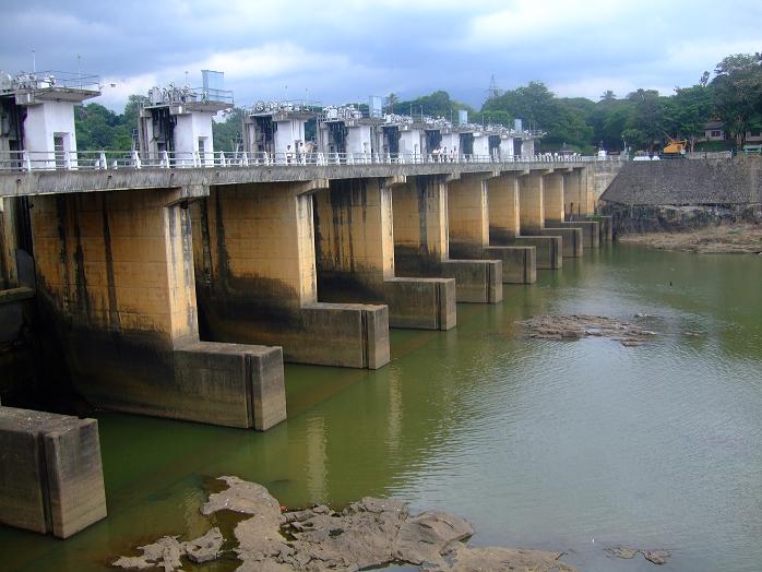
Polgolla Reservoir/Dam
The water resources of the Mahaweli Ganga
Basin and its utilization for agricultural and power development, as
well as for other uses had been studied over a period of four years and a
Master Plan was prepared accordingly. The Master Plan provided for a
step wise implementation of the Mahaweli Ganga development consisting of
15 multipurpose projects;
04 trans-basin diversion canals; and
several power stations, having a total installed capacity of 960 MW over
a period of 30 years.
The first project, Polgolla Diversion Complex consisting of a diversion dam built across the Mahaweli Ganga at Polgolla for diverting the waters of the river to the Dry Zone through five miles long an under-ground tunnel connecting Mahaweli to the Sudu Ganga, and Hydro-electric power station of 40 MW. An extent of approximately 140 hectares (350 acres) of land had been acquired for this complex.
Historical Background
A UNDP/FAO team with Sri Lankan counterparts carried out a survey of the Irrigation and Hydro-Power potential of the Mahaweli Ganga and the adjoining river basins during the four year period 1965-1968 and formulated a Master Plan for the development of the available resources. The Master Plan is described in the three volumes on “Mahaweli Ganga Irrigation and Hydro-Power Survey” FAO, Rome in 1969.
The plan envisages the development under irrigation of 900,000 acres of land and generation of 2,037 million kilowatt hours of hydro electric energy from an installed capacity of 507 megawatts. The capital cost estimated in 1968 was Rs. 5,583 million, excluding cost of activities resulting directly from the project, but having their own economic justification, estimated at Rs. 1,120 million. In view of the large magnitude of the work and investment involved, the Master Plan was divided into three phases for purposes of implementation.
Phase I of the Master Plan for which feasibility studies have been prepared by the UNDP/FAO team has been sub-divided into three projects. The sub division of Phases II and III was left to a later stage when execution of the projects is taken up for consideration. Each of the projects in Phase I, and Phases II and III were individually evaluated and found to be economically viable. Each project can be constructed in a period of 4 to 6 years. The entire master Plan was phased for stepwise implantation over a time period of 30 years.
Implementation:
Execution of Project I of Phase I was commenced in 1970 and completed in 1977. It comprises of a barrage across the Mahaweli Ganga at Polgolla to divert a maximum of 2,000 cusecs through a 5 mile long pressure tunnel to a power plant of 40 MW installed capacity situated in the adjacent Amban Ganga basin. The tail race water flows down a tributary of the Amban Ganga into a reservoir at Bowatenna formed by a concrete dam across the river, which diverts part of the flows into the adjacent Kala Oya basin, through a 4 Mile long tunnel and a Tran basin canal into Kalawewa and Kandalama reservoirs. The rest of the diverted water along with the natural flow of the Amban Ganga is sent down the river to be diverted at the existing Elahera and Angamedilla diversion weirs into existing conveyance canals. The total extent of land benefited by Project I is 132,000 acres of existing fields and 91,000 acres of new lands.
The discharged of 1,300 cusecs is sent farther down the Amban Ganga and diverted at the Elahera anicut through Elahera – Minneriya- Kantalai-Yoda Ela canal to Minneriya, and from there to Kaudulla and Kantalai tanks, which supply water to system D-1. The Mahaweli System ‘G’ is irrigated directly from this canal.
The remaining 700 cusecs is transferred through the Polgolla-Kala Oya canal (P K) to Kalawewa and Kandalama tanks, from which 70 percent of System ‘H’ is irrigated.
- Installed capacity
18.3 MW X 2 - Expected annual average
energy 190 GWh - Commissioned in 1976
- Main contractors
- Civil – Mahaweli Development Board
- Electromechanical – Mitsubishi
- Hydro mechanical – Mitsubishi
- Located 15 km north of Kandy
- Reservoir (Polgolla)
- Catchment area : 1316 km2
- Usable water volume : 2.47 MCM
- Maximum level : 440.9 m above MSL
- Minimum level : 438.3 m above MSL
- Headrace
- Modified Horse shoe concrete lined (partially)
- 5.94 m diameter
- 8062 m length
- Penstock
- Steel circular, 3.96 m diameter, 381 m length, With surge tank
- Tailrace
- Maximum level : 353.03 m above MSL; Minimum level : 351.66 m above
MSL
- Maximum level : 353.03 m above MSL; Minimum level : 351.66 m above
- Generator (Mitsubishi)
- Conventional vertical
- 21400 kVA, 0.85 PF, 12.5 kV, 988.4 A
- 50 Hz, 20 poles, 300 rev/min
- Exciter : 125 V, 953 A
- Turbine (Mitsubishi)
- Vertical Francis
- Output: 18.79 MW @ 75.1 m effective head (Rated),
23.48 MW @ 89.39 m effective head (Maximum) - Rated discharge : 28.4 m3/sec
- 300 rev/min